This month we again
feature author/historian Robert C. Likes, and an article he
wrote for Desert Magazine in October, 1970.
Bob is also the author of
From This Mountain—Cerro Gordo, and at least four other
Desert Magazine articles. In past issues of EHC we have
featured his stories on Mono Mills, and Panamint City.
Through the magic of the
internet, Bob stumbled across our website and has become a good
friend, and mentor. He has been a source of constant
encouragement and source of information about many of our
favorite places, and just a delight to know!
Bob is currently in rehab
after suffering a stroke. The Likes family and close friends
encourage everyone to send good wishes and a line or two about
how important his works have been to desert rats and ghost
towners in the new millennium.
Even if you don’t know of
him or his works, he and his buddies at Rocketdyne who formed
the Ghost Town Club were the forerunners to modern day 4x4’ing,
and backcountry exploring, and we can thank them for paving the
way and preserving histories for us!
Please feel free to e-mail
Bob at:

The Southern
Emigrant Trail - later called The Butterfield Overland Stage Route -
stretched from St. Louis, Missouri to San Francisco. Probably the
deadliest section of the trail was through the desert areas of
Southern California.
GREAT
TROUGH in the Anza-Borrego desert area of San Diego County winds
through the desolate Carrizo and Vallecito Valleys and then rises
into the cool, green costal hills of southern California. This
natural passageway is the legendary Carrizo Corridor.
Along
its course of rutted and sandy washes flowed a steady stream of
California history, for this was the last leg in the journey along
the southern Emigrant Trail and the colorful butter field overland
Stage Route.
Kit
Carson passed this way in 1846, guiding General Stephen Watts Kearny
and his dragoons through the corridor when it was nothing more than
a wilderness between waterholes. One year later, Colonel St George
Cooke and his Mormon Battalion followed Kearny’s route and
established the first wagon road into Southern California. This
wagon road became known as Cookes Road, or Sonora Road, until the
discovery of gold brought a flood of Americans westward in 1849.
From this date on, it was called the southern Emigrant Trail.
In 1850,
great herds of sheep and cattle were driven across the old trail to
feed the exploding population on the west coast. Because thousands
of animals perished and left a trail of bleaching bones from Yuma to
the Carrizo Corridor, the southern Emigrant Trail was called the
Jornada del Muerto - Journey of Death.
By 1856, the
United States Government realized it had a growing communication
problem with this far-flung empire on the Pacific coast. A mail
contract linking San Antonio with San Diego was awarded in 1857. The
first mail crossing the Colorado Desert and through the Carrizo
Corridor on mule back was known as the “jackass Mail.”
A second and
larger contract was awarded to John Butterfield in 1858. The first
mail pouches were loaded aboard the departing Butterfield Stage in
St. Louis, Missouri, and in exactly 23 days, 23 hours and 30
minutes, the mail pouches were safely delivered in San Francisco,
California, more than 2800 miles away.
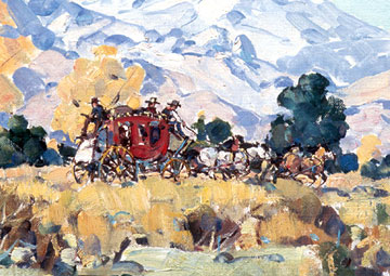
 |
|
The
Butterfield Stage makes its way to California. |
Exploring the
Butterfield Overland Trail from the vanished Carrizo springs Station
to the old Warner Adobe reveals the least spoiled section of its
entire route in California.
Although this
section was the gateway to the promised land, it is doubtful that
the traveler looked forward to making the passage. With its annual
rainfall of something less than five inches, this lonely land
supports only an arid growth of ocotillo, cholla and indigo brush,
though there are stands of smoke trees and mesquite in the washes.
In 1847, Colonel Cooke described the eroded hills and rocky slopes
as “…the worst 15 miles of road since we left the Rio Grande.” When
the Overland Stage established a route through the corridor, it was
the epic battle of man against the elements, with a succession of
Indian raids, holdups and accidents, thrown in just to make it
interesting.
The Carrizo
Gap, through which the Carrizo Wash passes, is the eastern entrance
to the Carrizo Corridor. Following this route, the butter field
Overland Stage located the first way-station at Carrizo Springs.
This section of the old trail crosses a navy bombing range and
special permission is required before entry. The stage station at
Carrizo Springs has completely vanished.
After leaving
Carrizo Springs the old stage road followed the Carrizo Wash east
until it reached the junction of the Vallecito Wash. Turning up the
Vallecito Wash, the trail plowed through the sand to a point nine
miles from the Carrizo station where it left the wash to reach Palm
spring, a short distance away. The first native palms,
Washingtonia filifera, seen in California by a non-Indian were
the ones at Palm Spring. Pedro Fages first described the palms in
1772. Sixty-five years later Colonel Cooke reported a clump of 20 to
30 palms at the spring, but by 1853, after a steady stream of gold
seekers, the number of palms had dropped to three or four.
When the
Butterfield line built an animal changing station at the spring in
1858, the majestic grove of palms had been reduced to a few burnt
stumps. Today the site of the Palm Spring station is marked by a
monument standing in a clump of green mesquite, and three small
palms. The spring still provides water at this small oasis, and the
serenity is in marked contrast to the flurry of activity that took
place when this was a vital oasis along the Butterfield Trail.
After leaving
Palm Spring, the old road continued following the shifting sands of
the Vallecito Wash until it reached one of the most famous way
stations along the route. Vallecito was the first oasis with an
abundance of water and green grass, providing welcome relief for the
weary passengers after days of exposure to the hat and glare of the
desert.
W. L. Ormsby,
a passenger in 1858, commented, “….a perfect oasis,” then went on to
say, “ …a most refreshing relief from the sandy sameness of the
desert.” The Vallecito station was originally constructed of
sod-bricks with a roof of hand-hewn beams, pegged and tied in place
with rawhide, then covered with willow poles and tulles before a
final topping of sod. The famous station was reconstructed in 1934,
and today it is a San Diego County Park.
Many colorful
stories centered around the Vallecito stage station. One such
account was the night “Ol’ Bill,” one of the drivers, was held up a
few miles south of the station. Five men on horseback engaged in a
running gun battle with the passengers on the stage as Ol” Bill had
his team going “hell-bent-for-leather.” Just when it looked as
though the stage might reach the safety of the Vallecito station,
one of the animals on the team was shot and the stage came to a
terrifying halt.
Using the
coach for cover, “Ol’ Bill and his armed passengers continued to
hold of the bandits, forcing them to retreat. After another volley
of gunfire, the bandits rode off into the night. Soldiers who had
been stationed at Vallecito and who had heard the shooting, came
riding up just as Bill was cutting the dead animal out of the
harness. After a brief exchange of words, the soldiers rode off in
pursuit of the outlaws and bill headed the stage toward Vallecito,
feeling sure the bandits would be caught.
The next
morning, Ol’ Bill was astonished to see there were no prisoners.
When questioned about this, the corporal in charge of the detail of
soldiers smiled, then replied, “Well, let’s look at it this way,
bill. Vallecito has no accommodations for prisoners - outside of the
graveyard, that is.”
From
Vallecito, the road went west, gradually gaining elevation until it
reached the upper end of Vallecito Valley, where it turned and
entered a narrow canyon. This was the only passageway between
Vallecito and San Felipe Valleys, and it was here that Colonel Cooke
and his men were almost defeated in their attempt to blaze a wagon
road into Southern California.
“I came to the
canyon and found it much worse than I had been led to expect,” Cooke
later reported, “…there are many rocks to surmount, but the worst is
the narrow pass.” All of their road building tools had been lost
when the party forged the Gila River in Arizona, so axes were used
to increase the opening. Even then, the chasm was too narrow by a
foot of solid rock, and Cooke ordered the wagons to be taken apart
and carried through. It required two days for the men to work their
way out of the canyon. The pass was widened for the Butterfield run,
and was known as Cookes Pass or Devils Canyon.
For some
unexplainable reason, the pass now bears the name of Box Canyon, and
for obvious reasons, it is by-passed by the paved highway. There is
a historical marker here, and a parking area from which you can look
down into this famous pass. However, a far more rewarding experience
is to climb down into the narrow defile and view it from the same
perspective that confronted Cooke in 1847.
Box Canyon was
the end of the Carrizo Corridor and the old stage route became
easier as the team of horses followed the rutted ribbon into more
open country. After crossing a dry lake bed, the trail led straight
up a rocky ridge with a grade so steep passengers had to get out and
either walk up or push the coaches up the incline. Because of this,
the ridge became known as Foot and Walker Grade. Upon reaching the
summit, the course ahead became routine and allowed the coach and
exhausted passengers to move swiftly through the lower reaches of
the San Felipe Valley. The next stop was the San Felipe Station. The
site is located on private property just north and a little west of
Scissors Crossing.
The next 16
miles of the pioneer trail continued north through the increasingly
fertile San Felipe Valley and crossed another pass before it dropped
down between the rolling hills surrounding the station at Warner’s.
The historical
marker at the old Wilson Store proclaims it to be the butter field
Overland stage station, yet according to historian William Wright,
this structure had not yet been built when the Butterfield Stage
discontinued operations in 1861. Wright claims the Wilson Store was
one of the two buildings constructed in 1863 at a spot known as
Kimbleville. He acknowledges the Wilson store was later used as a
stage stop, but not for the Butterfield line. Instead Wright says
the old Warner adobe, built in 1849, is the real Butterfield stage
station. The Warner adobe is located one and a half miles north of
Wilson’s store, and equidistant between the San Felipe Station to
the south, and the Oak grove Station to the north. However, both the
Wilson store and the Werner adobe are historic landmarks, and worth
the time to visit.
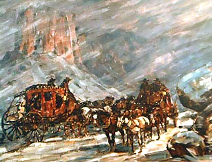
 |
|
Old
Stagecoach Trail, by Margorie Reed, 1958.
Original painting at the Wells Fargo History Museum
Old Town San Diego, California. |
At Warner’s
the trail branched, one heading southwest to San Diego by way of
Santa Ysabel; the other pressed on in a northwest direction across
the small valley and through the hills until it reached the Oak
Grove Station ten miles away. The store at Oak Grove utilized the
foundation and ancient walls of the original Butterfield Station.
From here the stage route generally followed what is now State 70
until it reached Temecula, with a stop between at Aguanga.
With the
termination of the Butterfield Overland route in 1861, the decline
of the Southern Emigrant Trail began. More northerly routes were
being discovered and used, particularly the Cajon and San Gorgonio
passes. New routes were being used from San Diego to Yuma via Camp
and Jacumaba, and even the discovery of gold in the mountains west
of the old trail in 1870 did little to revive its use.
In the early
1900s, the pioneer trail through the Carrizo Corridor lay almost
forgotten. It was simply a road that “began nowhere, and ended
nowhere” - a sad epitaph compared to the address Colonel Cooke gave
his men upon completion of their assigned task.
“History may
search in vain for an equal march of infantry,” he said. “We have
dug deep wells which the future traveler will enjoy…..we have worked
our way over mountains….. hewed a passage through a chasm of living
rock more narrow than our wagons…and thus marching half naked and
half fed, and living upon wild animals, we have discovered and made
a road of great value to our country.”
Much of this
famous route lies within the boundaries of the Anza-Borrego Desert
State Park, and so the areas of historic interest are preserved for
present and future generations to see and appreciate.
Read
More about the Butterfield Stage
Adventure No. 12 Anza-Borrego State
Park:
http://www.parks.ca.gov/?page_id=638
Vallecito Station
http://www.aroundandaboutsandiego.com/vallecitostagestation.html
Phantoms Of Vallecito Station
http://www.legendsofamerica.com/CA-Vallecito.html
Life and Times Of the Vallecito
Station by Ruth MacGill
http://www.gather.com/viewArticle.jsp?articleId=281474976972513Life
|